
WHAT
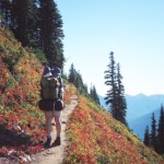
Olympic National Park is one of the most frequently backpacked parks in the national park system. The variety in terrain, distance, difficulty and extensive wilderness, adds to the allure of an endless combination of trail segments.
WHERE
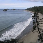
 There are 660 miles of trails in the Park—potential for a life-time of backcountry experiences. There are trails to suit the taste of anyone willing to take up the challenge, with an abundance of up and down and little in the way of flat. The longest near-flat hike in the Park, except the Coast, is the first 10 miles of the Hoh River trail. These trails deliver the Park’s magnificence in every way possible.
WHEN
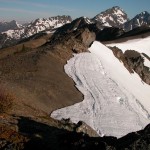
 Usually the trails in the highest reaches of the Park are reasonably snow-free by late July or early August, and the snow usually doesn’t return to the Park until late October. Following the rules, being prepared and informed, and knowing your limits are critical to a memorable and joyous experience. Here’s some information to help get you started.
HOW
Maps
There are two kinds of useful maps to be familiar with for planning and taking your trip. The first map—most useful for planning a backpacking trip in the Park—is the Olympic Wilderness Trip Planning Map. This map is a planning tool only.
The second is a detailed topographical map. Brown’s Outdoor in Port Angeles carries Custom Correct Maps. Custom Correct, a local company produces the best and most accurate topo/ hiking maps for Olympic National Park. For hiking in the Olympic National Forest, I recommend the digital interactive visitor maps provided by the National Forest Service at https://www.fs.usda.gov/main/olympic/maps-pubs
In fact, a topo map is the first of the “ten essentials” to include on your trip. Don’t leave the trailhead without all ten essentials! Ten Essentials on Wikipedia.
Here are a few tips to orient you to the Planning Map. As my example, I’ll use the round trip route starting at the Obstruction Point trailhead, 7.8 miles southeast of the Hurricane Ridge Visitor Center:
- Get a wilderness permit by going on-line to Recreation.gov.
- Take note of the trailhead elevations, which are posted for most trailheads. At Obstruction Point it is 6, 150 feet.
- Note that dashed lines indicate improved trails and include segment distances, –‘——‘– between hash marks.
- On the map, Grand Lake’s is a designated Δ red tent area, which requires a reservation.
- The trail continues to Grand Pass. Note that the rest of the 4.4 miles down to Cameron Creek is on a primitive trail that is often difficult to follow, and is indicated on the map by a series of dots (…..).
- The trail continues north to Three Forks, where you’ll notice a brown tent (Δ A brown tent does not require a reservation), then to Deer Park, where a front country car campground is indicated by a green tent (Δ green tent).
- Finally, head west across Maiden Peak and Elk Mountain back to Obstruction Point.
What this example and the Planning Map did not identify was the topography. So when looking at the planning map you didn’t learn that:
- Obstruction Point to Grand Lake loses 1,560 feet in the last 1.4 miles, and then regains it in the next 2.2 miles up to Grand Pass.
- The drop from Grand Pass to Cameron Creek is 2,200 feet in only one mile.
- Three Forks to Deer Park is a climb of 3,040 feet in 4.3 miles.
In addition to the loop hikes as short as overnight to over ten days in length, there are a number of “through-hikes,” such as:
- Whiskey Bend in the Elwha (el-wa) to North Fork on the Quinault (quin-alt) River.
- Graves Creek to the Upper Dungeness trailhead.
- Sol Duc (sal-duck) trailhead to the Hoh (ho) trailhead.
These are just a few of many possibilities. The biggest challenge when “through-hiking” is transportation to or from a trailhead. You might consider splitting your group in two, hiking from both trailheads and swapping car keys when you meet in the middle of the hike. I can’t recommend a transportation solution to through-hiking. You may want to review your loop hiking possibilities as an alternative.
Regulations and Precautions
The regulations for wilderness travel are routinely enforced. To avoid any problems, include in your trip plan time to familiarize yourself with the regulations. Speak with any of the Rangers at the Park’s Wilderness Information Center or visit the Wilderness Permits page on the National Parks website.
Also, be aware of the following:
-
- Giardia is present in the Park’s water bodies. All water in the backcountry must be filtered, chemically treated, or boiled (at a rolling boil) for a full five minutes. If filtered, the filter must be for particles of 0.5 microns or less; that’s the size of the parasite and its cysts. For more information, visit the Wikipedia page on Giardia.
- Open fires are not allowed above 3,500 feet in the Park. You can expect to see signage on the trails to that effect, but signed or not the 3,500 foot rule applies. Refer to the Wilderness Camping page on the National Parks website for more detailed information.
- Your backpacking trip encroaches on the natural state of the backcountry. As a guest in this primitive environment, it is your duty to avoid leaving your mark upon it. Millions have hiked with care and respect before you and for your benefit; pay it forward for all who will come behind you.
- Mosquitos and deer flies can be bothersome between the last frost of spring and the first frost of fall. Insect repellant is suggested and I recommend a Deet-free, eucalyptus-lemon oil type. It’s not greasy, doesn’t eat your clothes, won’t harm your liver, smells nice and it repels very well.
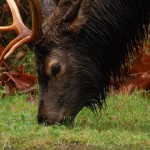
- Never feed the animals. By feeding them you habituate them to humans. When they lose their natural tendency to avoid contact with visitors, bad things can happen. They need to forage on their natural and usual feed resources. It provides them with the nutrition and fat stores required to survive the harsh winter months.
If you chose a hike that starts in the National Forest, usually on the east flank of the Park, finding the trailhead can be tricky. The US Dept of Agriculture—Forest Service website allows you to download free topographic maps showing roads and trails in the National Forest. You might also be interested in checking out Kaiyote Tours.
Many backpackers fly to Port Angeles to get to the Park. This page on the TSA website contains important information about traveling with stoves and fuel: Transportation and Safety Administration
Finally, the only book that I recommend on backpacking in the Park is: Olympic Mountain Trail Guide, by Robert L. Wood. I believe that it is the seminal authority on the matter, written by one of the few hikers I know who have hiked every mile of every trail in the Park and US Forest. You can order the book from Discover your Northwest, or call David (the manager of DYNW) directly, at (360) 565-3195. If you purchase the book from them, they will donate a portion of the profit from the sale to Olympic National Park.
Here are two additional Park web sites useful to backpackers: